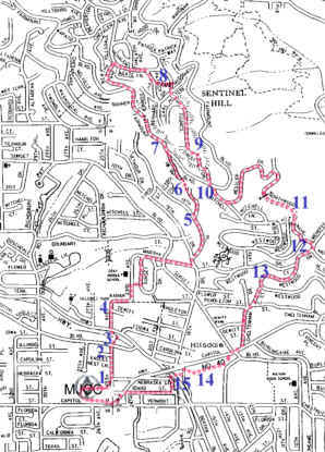
| 1.
The back door of the parking lot: it’s a path and steps down to 25th Ave.
2. We go north on 25th Ave past “Eagle’s Nest,” a little hidden pocket community in a bowl behind the hills above the old electric railroad line (now Bertha Blvd) and below MJCC. 3. We cross Bertha Blvd and drop into the uppermost part of Fanno Creek. This is a trail for the school children from Robert Gray Middle School. A pedestrian traffic light makes crossing of Beaverton-Hillsdale Hwy easy. 4. Hillsdale Park. A secluded gem many long-time nearby residents don’t know is there. Largely undeveloped, it includes an old orchard, a hill in the middle with a shady park bench, and a wild-grass meadow where dogs sometimes play. 5. 18th Drive and 18th Place part company. We take 18th drive, which looks like a driveway going up the hill. These streets confuse many a delivery person because the “Drive” and the “Place” seem to be reversed. In fact, the narrow Drive is the original road leading from Hillsdale to Fairmount Blvd. 6. 18th Drive turns into a path which has been surfaced by volunteers and now is an excellent all-weather route through the woods. It goes through a large land slide which wreaked havoc as far away as the corner of Dosch Rd and Beaverton Hillsdale Hwy. 7. Fairmount Drive, at about 950’ elevation, rings the southern tip of the Tualatin Hills. We go north on it to Bertha Ave, a steep street leading up to Council Crest Drive. Fairmount Drive has fine views of the Tualatin Valley side of the Tualatin Hills. 8. We go south on Council Crest Drive and turn onto Patrick Place to go to Healy Heights Park and its drinking fountain. Then we return to Council Crest Dr by crossing the park. 9.
The southern end of Council Crest Dr is at the transmission towers on Healy
Heights. From here we have fine views to the east and the Cascade
Peaks. A surfaced path leads past the big red and white tower (which
carries many different signals) 10. We drop down off the mountain on Mitchell where we get fine views to the south. This is the top of a route known to many runners as “The Death Run” because of the elevation gain from The Chart House on Terwilliger Blvd. We turn onto Hessler Dr and pass homes that have spectacular views of the city. 11. The Nature Conservancy has recently purchased a large piece of land between Northwood Ave and Terwilliger Blvd, protecting the wild hillside here. Northwood Ave was blocked off to auto traffic many years ago, and recently it was given an all-weather surface for walkers to enjoy (by the same volunteers that surfaced 18th Drive). Here we pass through dense woods. 12. The Nature Conservancy land touches Westwood Drive near Menefee. We pass a spectacular flower garden containing many unusual species. 13. Most street corners on this hill are corners of Westwood and Westwood (Drive, or Lane, or View, or…). We descend on Westwood Drive (which snakes back and forth down the hill) and pass one of the big city water tanks that supply our household needs. 14. After switching from the Westwoods to the Cheltenhams we reach the bottom of the hill at the little mountain pass which is the community of Hillsdale. Fanno Creek drains to the west; Stevens Creek drains to the south; an unnamed creek drains to the east and into the Willamette River. We cross Beaverton-Hillsdale Hwy at the Sunset traffic light and go through the pharmacy parking lot onto the new Rieke soccer field, a recently constructed, all-weather artificial turf field. 15. We pass the old bridge which once went over the electric railway line at Bertha Station. There’s a set of concrete stairs hidden under the weeds. We take a short cross-country trek to cross Bertha Blvd and get to The Turning Point, a new affordable housing project subsidized by the city. Idaho St makes a nice back-street return to MJCC. Download
route description page for printing.
|
.
.  Click
on map for a high resolution copy you can print.
Click
on map for a high resolution copy you can print.
|