| 1.
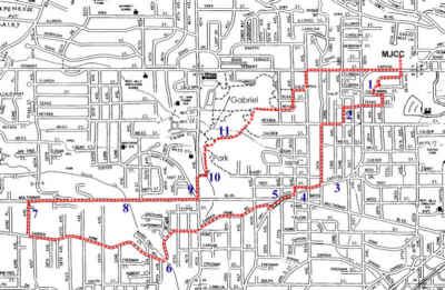
Steps behind Hillsdale Terrace lead up to California St, passing the basketball
court and under an Italian Prune plum tree. We turn east on the primitive
California St to take the even more primitive 28th Ave. Several very
old homes are still located in these blocks.
2. The top of the hill has a city water tank with a large pear tree on its northern side. More primitive streets take us south to Nevada Ct, and then to 34th Ave and south to Capitol Hwy. 3. Capitol Hwy was the main route from Portland to Salem. Here, it follow a ridge top from Hillsdale to Multnomah Village to the pass at Taylors Ferry Rd. Here in Multnomah the old school has become the Multnomah Arts Center, which houses many activities in addition to arts classes. SouthWest Neighbors, Inc (SWNI), Senior Center, a child care center, and the neighborhood police contact center are located here. 4. Multnomah Village, once an outlying community, now a Town Center within the city of Portland, full of thriving businesses and citizens with a lot of civic pride. 5. An old Bridge that once took Capitol Hwy over the Electric Railroad tracks. Multnomah Blvd now runs where the railroad ran. 6. Garden Home Rd once was the route from Multnomah to the community of Garden Home. Being a auto route not a railroad route, it climbs ridges and dives into streambeds, making a roller-coaster route for the walker, runner or cycler. 7. From Garden Home Rd the connections to Multnomah Blvd to the north are scarce. 61st Ave give pedestrians a route via a short blackberry lined trail. 8. Multnomah Blvd benefits from the need for railroad routes to be very flat. Along this street you can see the numerous cuts and fills that were made with shovels and horse drawn wagons. Some of the stream crossings were originally by trestle, but all these have been replaced by dirt fills. West, at the village of Garden Home, the route split into a track west to Beaverton, and a track southwest to Tigard. The remains of these routes can still be seen in many places. 9. At the corner of 45th Ave and Multnomah Blvd a branch of the railroad split off to the northwest. This is now Maplewood Rd, also flat and constructed with cuts and fills. An large nursery was located on the top of the hill to the west and a little north of this intersection. 10. A "demand trail" (one that exists simply because people use it) enters the southwest corner of Gabriel Park from the end of the apartment's parking area. 11.
Gabriel Park, one of Southwest Portland's larger parks. It offers
a variety of playing fields, meadows, forests, a wetland, a off-leash dog
run, and a large new community center. The woods and wetlands were
suffering from overuse and have recently been the subject of restoration
efforts by a variety of neighborhood and conservation groups.
Download
route description page for printing.
|
Click
on map for a high resolution copy you can print.
Click
on map for a high resolution copy you can print.
Click
on map for a high resolution copy you can print.
|
