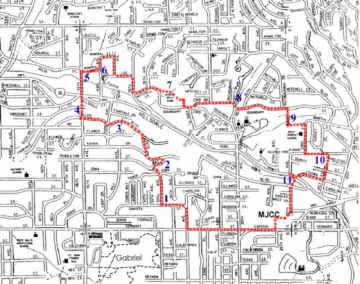
| 1.
This route starts by following the ridge to the west and north. At
37th and Dakota, the route starts descending into Fanno Creek, which flows
west along side Beaverton-Hillsdale Hwy. Fanno Creek ends at the
Tualatin River in the town of Tualatin.
2. These streets wind along a steep, forested hillside. Shortly past Iowa St we turn down the very steep Tower Way, then take 39th Ave to Cullen Blvd. 3. Cullen Blvd is blocked to vehicular traffic here because of a landslide that destroyed a home below on Fairvale Dr. Local homeowners discovered that this street is not owned by the city, and they are reponsible for bringing the street up to code. 4. 45th Ave becomes a trail north of Cullen Blvd. The trail between Cullen and Fairvale is rather ephemeral and has been washed out by rain and blocked by fallen trees in the past. The trail between Fairvale and Beaverton-Hillsdale Hwy is well-defined and actually has homes with addresses on the trail (as 45th Ave). 5. A hard-surfaced trail (easily missed) leads east of 45th Ave, just south of a bamboo hedge. It passes over a branch of Fanno Creek behind some apartments and up a set of steps (with a bike rail). 6. 43rd Ave here looks like a paved driveway to the south, and is an interesting route to return to Beaverton-Hillsdale Hwy. But we go north to Admiral St and 42nd Ave. We then take a jagged route to Albert Kelly Park. 7. Albert Kelly Park, named for one of the early settlers, offers a variety of ways through. Easy routes lead to most of the nearby streets. We take the abandoned street south to Boundary St. Then north and east on 33rd Dr to Dosch Rd. 8. Where Dosch Rd turn south, a road leads north through deep forest into Dosch Estates. This development of fine English style houses has preserved the forest and the old Colonel Dosch house—in the center of the development. Several Portland Heritage Trees are located around the old home. 9. We go east on Boundary to a paved path just past Richardson Dr. (It is just before a short steep rise on Boundary.) This path goes over a long, high bridge that was built for Gray Middle School students. Just past the bridge, we turn east and walk up a grassy slope (which is undeveloped Martha Street). 10. At the end of 23rd St, Kanan Street extends east into a trail and passes above a pond which frequently had wild ducks landing. (Bald eagles have been seen in this area, too.) Watch for a huge slingshot on the right. Just before the narrow street rises sharply, a path lead to the south and to 21st Ave. 11.
After dropping steeply down Iowa St we walk to the pedestrian signal at
25th Ave, cross and take the school kids path down into Fanno Creek and
up to Bertha Blvd (the old railroad bed; also nice and level). Graveled
25th Ave leads to the back door into MJCC's parking lot (a trail up the
steep bank).
Download
route description page for printing.
|
Click
on map for a high resolution copy you can print.
Click
on map for a high resolution copy you can print.
Click
on map for a high resolution copy you can print.
|
