| 1.
This large basin, the upper reach of Stephens Creek, was the estate
of the Raz family (Raz Transportation). Not too long ago cattle
grazed in these fields, but now it's occupied with large apartment complexes
and the Greater Portland Bible Church.
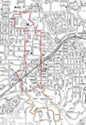
2. The southeast corner of the remaining empty field is bordered by large evergreen trees and part of an abandoned orchard . . . and is home to a frisbee golf course. 3. SW 19th Ave was once a crude road up and over the big hill south of Capitol Hill Rd. Today it's mostly pedestrian path connected by a few short pieces of paved street. This is on the new system of Southwest Portland pedestrian trail routes adopted by the Portland City Council. Steps lead from a dead-end piece of 19th to Barbur Blvd above. 4. South of Barbur, 19th goes over another hill, and is (marginally) driveable. Some ancient Douglas firs still stand near the top of the hill. The last several blocks before Taylors Ferry Rd are nice walking, but almost impossible driving. 5. An interesting extension of this route is to go south on 18th Pl to the northern end of Marshall Park and then take the main trail through the park to Maplecrest Dr. Marshall Park was once the site of a rock quarry, and rock cliffs remain in the park. The park extends south along branches of Tryon Creek all the way to Tryon Creek State Park. Trails run through the northern parts of the park but do not extend to the Tryon State Park trail system. Following Maplecrest to 18th Pl, and 18th up to Broadleaf, we reach Lancaster Road. This street winds in an out of the gulches of upper Tryon Creek and passes a new, undeveloped, addition to Marshall Park about a quarter mile north of Broadleaf Dr. [This route extends the loop to 5.4 miles and the elevation gained to 640 feet.] 6. Taylors Ferry Road is one of the many Portland routes associated with river crossings in the early 20th century. Boones Ferry crossed the Willamette River south of Wilsonville (just west of the present I-5 crossing). Scholls Ferry crossed the Tualatin River at the town of Scholls. Taylors Ferry crossed the Willamette River near the present Selwood Bridge. 7. SW 26th Ave parallels the north branch of Tryon Creek here and passes near the old Pine Hill property (historic house still there off Taylors Ferry Rd near 28th). The field near the creek was occupied by elephant barns when used by a travelling circus. 8. SW 26th Way takes us under both I-5 and Barbur Blvd. This area as been planted with wild flower mixes which have splendid flower displays. Tryon Creek just north of Dolph Ct was recently the home of a family of beavers. 9. SW 25th Ave north of Multnomah Blvd is a pedestrian route (but not an auto route). It passes the National Guard Armory, a telephone company complex, and the West Hills Christian School playgrounds. 10. Custer Park. Recently refurbished with playgrounds, paved paths, and a storm water runoff abatement swale. 11. Nevada Ct is an interesting east-west route for pedestrains which is broken up with trails and paths, cutting off auto traffic. It has nice views of the Tualatin Mountains to the north. 12. SW 28th Ave is another steep, rutted gravel street giving the pedestrian all the advantages. Download
route description page for printing.
|
Click
on map for a high resolution copy you can print.
Click
on map for a high resolution copy you can print.
|
