 |
Here are some comments made by people on being told the maps have inaccuracies: "Please give me a verbal description of the way to get there: I'm confused by all those lines on that map." |
Who loves a mystery?
Lets make a game of it.
| Most Portland street maps show many, many miles
of fictitious streets and roads. Anyone who tries to use these maps
to get from point A to B will almost certainly be frustrated if point B
is more than several blocks from point A and not along some major street.
Try it! Pick a couple of random points on your map. Use the map to find the shortest route. Then go out and try to drive it. Good luck! |
For a sporting afternoon try taking your map
on a drive or walk through the neighborhoods near these intersections:
SW 45th Drive at Dolph Ct SW 39th Ave at Vesta St SW Pendleton St at 23rd Ave. Then, in Forest Park, there's NW Blyths Rd which leads to the small city below Lief Erikson Dr and built up along NW Royal Rd and NW Albert Dr. |
| .
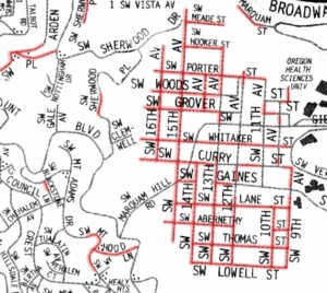
On these maps, the streets highlighted in red do not exist. Streets shown in green are there but are not shown on the map. |
|
Here are some comments made by people on being told the maps have inaccuracies: "Please give me a verbal description of the way to get there: I'm confused by all those lines on that map." |
 |
"That map shows the 'dedicated streets,' which city planners
need to know about; it's a good map."
"I found all the street names I was looking for on that map; it's a good map." |
 |
"That map shows the neighborhood association boundaries; it's a good
map."
"It's a good map, I don't see anything wrong with it." |
"I don't see anything wrong
with it."
???
| To a person who easily uses a map the things that are wrong are obvious. | To the person quoted above the "obvious" is unobserved: "I don't see . . ." |
Something about reading maps is at the edges of human comprehension.
and...
Map knowledge mightor might notbe useful...
(Much like the simple but
subtle science of man's recent history.)