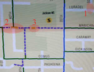
 2. Stairs are incorrectly shown. 3. This part of the route is a service road to the back of the school from 35th. It has a pipe gate at the school to stop vehicles but easy pedestrian routes go around the gate. The location of these "stairs" is an area that has been bulldozed flat and level. |
More like this. |
 |
 |
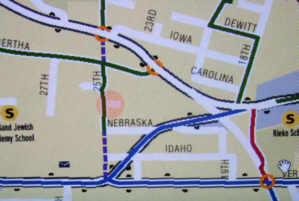 Portland Jewish Academy should be moved east almost to 25th. |
|
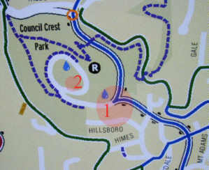
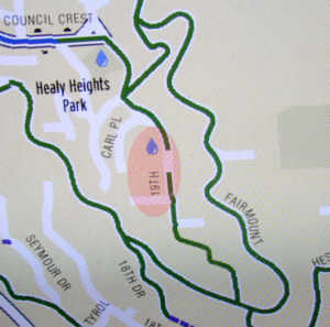
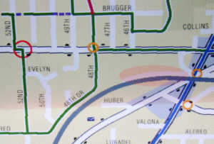
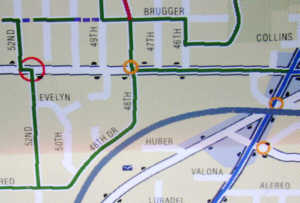
1. The stairs from Hillsboro are missing. The drinking fountain is south of Council Crest Dr at the top of the stairs. 2. The sculpture (Pioneer Woman) drinking fountain has been moved to this position. There are two drinking fountain inside the circle on Council Crest. |
 |
 |
I find this part of the map very confusing even though I'm familiar with these streets and stairs. Surely there's some way to improve the readability. |
 |
 |
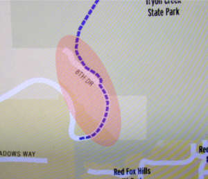 |
 Just for the
information, I've shown Knaus Rd, originally the only road into the Red
Fox Hills area and now a pedestrian/equestrian trail (with pavement showing
in places). Also the path from the end of Knaus to Briarcliff.
And the south end of Tryon Creek Park's Red Fox Trail. Just for the
information, I've shown Knaus Rd, originally the only road into the Red
Fox Hills area and now a pedestrian/equestrian trail (with pavement showing
in places). Also the path from the end of Knaus to Briarcliff.
And the south end of Tryon Creek Park's Red Fox Trail. |
|
Items
below here added
|
May 28: |
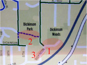 2. This is an open grassy area with no clearly defined routes or trails. It is very rough and the grass is very high: it's hazardous to walk through it. There are good trails in Dickensen Park in the woods. The best one drops down to the southwest starting from that curved section of Alfred and meets 57th north of Huddleson 3. SW 55th is mislabeled "Dickenson." |
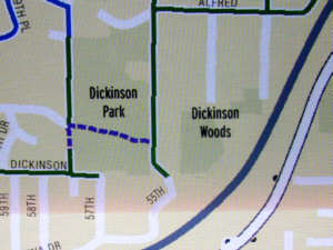 The Dickenson
Woods area has a system of trails constructed by volunteer neighbors.
The care of this park has recently been put under Fred Nilsen of PP&R.
Fred is the administrator who has taken such good care of Forest Park (and
the Hoyt Arboretum, and more). The trail system in the park is yet
to be determined. The Dickenson
Woods area has a system of trails constructed by volunteer neighbors.
The care of this park has recently been put under Fred Nilsen of PP&R.
Fred is the administrator who has taken such good care of Forest Park (and
the Hoyt Arboretum, and more). The trail system in the park is yet
to be determined. |
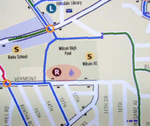 |
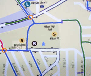 Note
the location of the Wilson High Pool. Also the positions of Rieke Elementary School and the Hillsdale Library. (Added May 30.) Note
the location of the Wilson High Pool. Also the positions of Rieke Elementary School and the Hillsdale Library. (Added May 30.) |
No way! |
 |
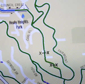
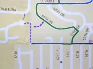
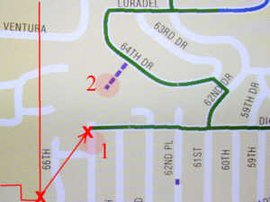 As best as I can figure it out, the City boundary has been displaced by the vector defined by the two X's. This error extends over a lot of the west side of the map -- maybe all. 1. SW 65th does not extend to Dickenson. 2. There isn't much of a trail in this BES area, but what there is turns west after coming off 64th Dr. |
 Even
though it isn't in Portland, and it's kind of private, I've shown where
the Ventura Development trails and stairs are at the park and up to Ventura
St. I've also tried to put the City Boundary where I think it belongs
(that's a little hard to do with this software). Even
though it isn't in Portland, and it's kind of private, I've shown where
the Ventura Development trails and stairs are at the park and up to Ventura
St. I've also tried to put the City Boundary where I think it belongs
(that's a little hard to do with this software). |
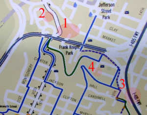 2. The path from the giant tree down to Vista is missing. 3. The problem here is with readablilty of the map. It's almost impossible to tell which streets cross the freeway, to tell the pedestrian how to get to the other side. Montgomery St needs to be named here. 4. I (dimly) recall a set of stairs here (I occasionally parked here to go to work at PSU and took the stairs from the dead end of 16th to the dead end of Harrison.) |
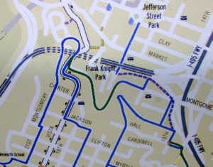 Here
you can see how showing the streets that cross over the freeway on bridges
vastly improves the readability of the map. Similarly, showing the
Freeway tunnel with dotted lines (the traditional map symbol for tunnels)
eliminates most of the confusion where Vista and Montgomery go over the
tunnel. Continuing the blue line over the loop on Montgomery helps
a lot, too. Here
you can see how showing the streets that cross over the freeway on bridges
vastly improves the readability of the map. Similarly, showing the
Freeway tunnel with dotted lines (the traditional map symbol for tunnels)
eliminates most of the confusion where Vista and Montgomery go over the
tunnel. Continuing the blue line over the loop on Montgomery helps
a lot, too. |
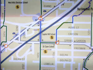
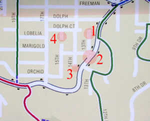
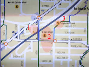 2. St Clair School is between Spring Garden Rd and Dolph Street. The west part of Freeman St between 17th and 19th is St Clair's playground. Pedestrians can usually use it. 3. Capitol Hill School is not here; it is where "St Clair School" is shown on the map. |
 |
|
Items
below here added
|
May 29: |
 |
 I've
made a few changes that make it much clearer what goes under what and what
actually connects to what. The fact that 4th goes under Terwilliger
is still not made clear. Putting a faint border on the N-bound on
ramp helps a lot show that 4th and 5th are underneath. I've
made a few changes that make it much clearer what goes under what and what
actually connects to what. The fact that 4th goes under Terwilliger
is still not made clear. Putting a faint border on the N-bound on
ramp helps a lot show that 4th and 5th are underneath. |
 2. I believe there are stairs here connecting to a driveway below, but I'll have to check it out. The property maps suggest that the southmost half block is a single property. I think that a driveway from Vista is for the several houses built in the north half and has stairs to access Montgomery. |
|
 2. SW 13th ends at Marigold and does not extend to Taylors Ferry Road. 3. The map makes it look like 14th comes much closer to Taylors Ferry Road than it does. I think it's because the white lines for streets are rather wide and Tayors Ferry Road is displaced a little to the left. 4. This piece of 15th is very primitive, narrow, and a little to the west of where it's shown. (It runs next to the house we were considering buying: we didn't think at the time it was anything more than a vacant lot.) |
 Many
of the streets in this area are rough (or very rough) gravel streets.
It's a difficult area to drive through, and that makes it a nice area to
walk through. Many
of the streets in this area are rough (or very rough) gravel streets.
It's a difficult area to drive through, and that makes it a nice area to
walk through.
|
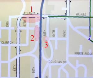 2. SW 66th needs to be more clearly separated from the freeway off ramp. They are as close as shown, but the width of the street symbol line is wide enough to overlap them. 3. No extension of Southview on the west side of 65th (I-5 northbound on ramp) exists. |
 I
recall that the street signs indicate that east of 68th the street is called
"Haines" and to the west it's called "Atlanta." I
recall that the street signs indicate that east of 68th the street is called
"Haines" and to the west it's called "Atlanta." |
|
Forgot this one!
|
|
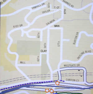
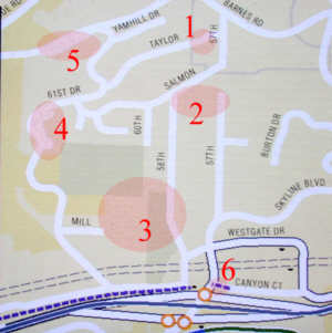 2. Main street connects 57th to 58th. It's extremely rough (sort of paved, though, I recall) and signs on it discourage vehicular traffic, but houses are located along its entire length. 3. Mill doesn't dead end. It continues up to the school property, turns north , becomes gravel, and goes to Clay, which goes to 58th. 4. and 5. I don't understand why these extra widths, or parallel streets, are shown. No 4 is, I believe, a private driveway to a large mansion. No 5 is one of several narrow streets for some tightly packed housing developments in this area--not clear why this one would be singled out. 6. Canyon Ct now has a long break in it as it comes up to Skyline. This may change as the big highway project is finished. Just noticed that the pedestrian path (wide and paved) shortcut going from Humphrey to the bus stop at the top of the eastbound Hy26 on-ramp at Slyvan is missing. It's right at the bottom of the above map, just below the right-most of the two traffic signals. Also, I'm pretty sure that street just south of it isn't 58th: it's Hewett. (Added May 30.)
|
 |