The mystery thickens.

We can dig up a good map, say a USGS topographical map, and try to solve the mysteries of where these errors came from. We do find some of the lines that are shown as streets, but on the good map they are not streets.  They might be any number of other things.

  
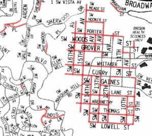
On these maps, the streets highlighted in red do not exist.  Streets shown in green are there but are not shown on the map.
SW 25th Ave is the location of a section line.  The map maker mistakenly took that section line to be a street between Sunset Dr and Martha.  Then, he mistakenly ended Mitchell St at 25th rather than at Richardson Dr.

The highlighted part of Martha St is a "dedicated street," owned by the city and available to be made into a street, but no street exists now nor is it likely there will ever be a street there.  This knowledge is useful, perhaps to a city planner, but useless and confusing to someone using a map for the purpose it was published.


Around the turn of the 20th century, this steep hill was purchased by a pair of Easterners who had never seen it.  The grid of streets was obviously drawn by someone who had not set foot on the terrain.  UPDATE

This Manhattan-like grid-that-never-did-exist—and never could— has remained on the books while the century marks pass by.  Some maps show 95 non-existent blocks here.


The "M" shaped street near the center of the map is actually the boundary between city and county land, mistakenly seen as a street by the map maker.

"SW 5th," in the northeast corner of the map is actually Boones Ferry Road, mistakenly connected to Terwilliger Blvd too far to the north.

Many street segments, far too many for this small piece of the map, are simply errors, sometimes dedicated, but unconstructed, potential streets, sometimes just simply carelessness.  SW 6th off Terwilliger was constructed after this older map was published, but many recent maps still don't show it.

The mystery gets even thicker.

As time goes on, and newer versions of these maps are published, we would expect the errors to get corrected.  After mapping  became a computer activity, rather than a drawing board activity, we should have seen great new improvements.

(This is not just a Portland, Oregon phenomenon.  We have found pretty much the same kind of errors on maps published for other urban areas.)

It just hasn't happened that way.  That grid of (up to 95) city blocks west of OHSU persists indefinitely.  Some maps have more phantom blocks than those shown here, some have fewer, but the map makers (almost) never seem to come close to getting it right.

When computers came on line, the maps got worse.  Even ODOT maps, which used to be practically perfect, are now showing many of the persistent errors.

Solving the mystery?