"You can't get there from here!"
Not with that map you can't.


If you enjoy long walks, sooner or later you'll get stopped by a motorist seeking directions. They will usually show you their map, and that map will be a masterpiece of creative cartography.  Almost all street maps of Portland are. You see whole communities of mapped streets that couldn't possibly exist because cars aren't mountain goats.  You don't see streets that do exist because the cartographer wasn't a walker or driver in the area, one who cares about accuracy.


Look at some of what you might find.


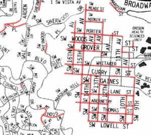
On these maps, the streets highlighted in red do not exist.  Streets shown in green are there but are not shown on the map.
You're driving east on Sunset Dr at SW 25th Ave and your map tells you that you can go south on 25th to Martha St.  Don't try it.

You would run over someone's lawn, assuming that you could drive through the high hedge.  It wouldn't do you much good to get to the corner of Martha and 25th: there, Martha St is a grassy hill with large Douglas Fir trees scattered here and about.  Also 25th south of Boundary is a path with a narrow pedestrian bridge blocked with pipes to discourage even bicycle travel.


Perhaps you're a student at the Oregon Health Sciences University, and you're looking for housing nearby in that small city west of the campus.

What you find there is deep, steep-walled canyons covered with dense forest which is  crossed by several miles of switchbacking trails.


You are trying to get to the north side of Marshall Park and your map indicates that you can turn onto 13th Ave from SW 12th Dr.

You do, and you immediately find someone's garage planted in the middle of 13th Ave.  In fact, 13th Ave looks a lot like Brer Rabbit's briar patch: a good place to pick blackberries in the late summer.

It's a real problem: many of the streets shown on that map simply don't exist and never did.

Accurate Map Index

What's going on here?