| Woods
Park Map
Forest Park Map Gabriel Park Map Hoyt Arboretum Map (270 kB) 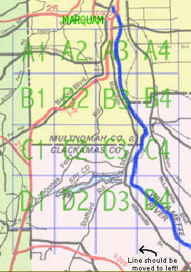
|
|
|
|
| Woods
Park Map
Forest Park Map Gabriel Park Map Hoyt Arboretum Map (270 kB)
|
|
| POSTED:
A1: 122kb some notes. A2: 129kb Curiosities. A3: 137kb Curiosities. B1: 161kb some notes. B2: 131kb B3: 103kb Marquam: 87kb The above maps have been updated (January 2002) and extended south to the city limits. The pedestrian routes on these maps are color coded according to quality. (These are larger files than in the past: download times will be a little longer.) Map B3 has been extended to the east to the river edge. PARTIALLY CORRECTED MAPS
UNCORRECTED MAPS
|
|
A composite map that combines A1, A2, A3, B1,
B2, and B3 and which prints on an 8-1/2 X 11 sheet (the JPEG file is
Want to see one of the other (unfinished) segments?
E-mail us and we will post it. NOW
We have other areas mapped too, and can post
some of them.
Explore
Portland
GIS
Geographical Information System
You start by entering a valid street address (or an address number), or a street intersection.
| Maps
Aerial Photography taken 1996, 1998, 2000 (Max res = 6") Assessor/Taxlot Information property assessments market values building descriptions Crime Data* Schools Parks Zoning Maps* Water/Sewer* locations of lines, connections, etc. Storm drains Natural Hazard -- earthquake hazard maps *For city of Portland, only. |
You get a choice of many data
sets to draw from.
You have a choice of many zoom levels on the maps and photographs. Output is viewable and/or printable.
These GIS maps are the planner's maps that often don't distinguish between constructed streets and "paper" streets, those rights of way owned by the city but not developed into real streets. They can be confusing and not very useful for route finding. Explore
Portland!'s maps have been made to solve this problem.
|
This is well worth the effort to learn to use. It's an incredibly rich resource.