| FRONT SIDE
Trail 7 going from Fairmount to Dosch -- IT'S NOT THERE AS SHOWN.
On both Urban trails map on back and on main map (where it's shown as light
stripe). This is where we avoid showing the route as going
down the water-meter trail. Isn't it better to show a gap in the
route? NC-3
The main trail, the Marquam Gulch Trail, in Marquam Nature Park is not
shown at all. Sunnyside Trail and Goldie Corridor Trail are shown.
Placements of switchbacks is, in general, wrong. Crossing of Marquam
Hill Rd by the lower branch of 40-mile trail is incorrectly shown.
It does not simply cross the street but runs along it for about 400 ft.
Marquam
Nature Park Map
Main Trail (center east-west trail) in Gabriel Park is not shown.
Tryon State Park trails are very incomplete. Auto entrance, parking
lot area, and Nature House need to be shown.
??[Check out end of High St north of Terrace.]
Grant St (abandoned name, but street not abandoned) not shown near Sylvan.
Access trail into cemetery not shown.
Mysterious streets in crook of Sherwood.
Big pedestrian bridge at parking lots near Ronald McDonald house (OHSU)
not shown.
In general, all streets should probably be named. (I've heard
several complaints on this issue.)
Wyndham does not go through to Skyline (just south of Hoyt Arboretum).
NC-1
??[Check street(s) south of Highland Rd one block south of Wyndham.]
[Check what appears to be an extension of Humphrey Park south of Humphrey
near Hilltop Ln. I think this is a private drive.
Why is there a dotted purple line show at the sidewalk on the south
side of Council Crest Drive from the circle to the park boundary?
The break in Sherwood is improperly shown.
Upper College is incorrectly labeled "Hall"
?? Check the angle of the stair sets below Upper Hall (the ones with
blue-painted wrought iron railings).
Curry between 11th and Vet Hosp Rd has a good trail. And 10th
is well-connected for pedestrians (parking lots, etc) between Curry and
Gibbs.
The Veterans Adm Hospital parking lots are formally connected with stairs,
paved walks and gravel trails. Probably should show a lot of these connections.
They are well-used.
The street and pedestrian connections and continuity at the east approaches
to Ross Island Bridge are unclear.
That grid of streets labeled "River Sq" between Montgomery River Pky
are, I believe, private paths and access to parking structures. They
are gated and locked?
What is the street to the east of Council Crest Dr just north of the
red/white transmission tower (Healy Heights)?
There must be some way to indicate that the gap in Council Crest Dr
south of Carl Pl is not a gap in drivability or walking access.
There's no right-angle wiggle in 21st north of Dewitt and south of Kanan.
Bertha west of 33rd has a sign, "Private No Trespassing." It's the Pascuzzi
property which Pascuzzi is contending vis-a-vis the Red Electric route.
36th does not extend north of Iowa at Iowa (Checked,
Aug, 04)
G-8 Flower Street does extend all the way to Cullen (west
of 42nd). It's a bit primitive for autos, but perfectly good walking.
There is a good trail from the dead end of 37th that goes through south
to Logan.
42nd south of Marigold is mostly street on its way to Primrose.
At the north end of the pedestrian bridge over I-5 below the Barbur
Transit Center, the main pedestrian route to the parking area parallels
I-5 to the west and is up a gentle concrete ramp. (We've never taken
the stairs shown as the route and have never seen anyone else use them
either.)
Old stuff
above
|
The main E-W trail in Dickenson Park
isn't shown--it goes to Alfred. The "trail" shown is a hazardous,
overgrown clearing with lots of hidden potholes--a real ankle-twister.
The planned trail up from Custer to 4th (shown in grey) is located under
the N-bound on-ramp. It does not cross 4th and 5th as shown.
The cemetery road approaching Sellwood Bridge is pretty far off.
The road goes north of the west end of Sellwood Br and then hairpin turns
south to the traffic light. There is a wide set of stone stairs from
the hairpin turn that goes down to the street near the end of the bridge.
The Summerville streets and path south of Carey are pretty far off:
too much street at the south end; too little at the north.
There are a lot more trails in the Quail Post development. North end
of Quail Post Rd is still wrong.
At Vacuna and 37th, there is street to the west. The path is in
the middle of the block.
The street that goes under the underpass north and east of Handy Andy's
is missing. (Capitol Hwy at Multnomah Blvd). So are the stairs down
from the bridge. The bridge should have black lines outlining the
bridge to show the third dimension configuration here. What is show
is very confusing and fails to give necessary information.
?[Check Hume at 42th/43rd.]
Lobelia does not extend from 5th eastward to Taylors Ferry Rd.
New trails have been located and marked in the Dickenson Woods parts
of Dickenson Park.
A well-established and well used trail goes through the north part of
Dickenson Park from 57th to Alfred Ct.
Check north side of PCC Slyvania Campus: entry at 53rd? There
are other paths, too, but less formal, 51st/Vesta, e.g.
BACK SIDE
North West
Most of the Catlin Crest development is gated and locked. The map should
somehow convey this fact.
Good News! The west end of Raab Rd has just been reopened to walkers
and bikes to Canyon Dr.
The position of Raleigh Hills School makes it look like the access to
the schools is on Hazelnut Ln. It's on Scholls Ferry Rd.
South West
There are no stairs (or any other pedestrian route) from the east end
of Pine Ridge Ct to 73rd. (IS THERE??)
Trail missing at northeast corner of Hideaway Park. It goes to
Hickman Ln--not named on map: is there really a piece of 67th here?
Aloma Way and what appears to be an extension of Canby is still wrong:
these do not connect in any way. Aloma Way goes to the Frank Estate
development around "Firlock Way" and nowhere else (as far as I know).
There is a high quality path that connects the athletic building for OES
to the OES campus, and this path can be reached from Frank Estate by a
couple of ways (across a back yard of an apartment and over a wier on the
stream) but this path has a gate that is often closed and locked.
The gates that were put in to connect the path to Arranmore development
have all be closed and locked.
The paved path north out of Garden Home Park to Skyhar is missing--and
so is the water fountain near the tennis courts. (We rely on this
water a lot.)
Monshadow Park trails all missing
74th--Barbara to Landau has roads and a trail (with bridge). It
just doesn't connect by auto.
Spruce St west of 77th has good pedestrian connections all the way to
Hall.
The gap in Elmwood between 80th and 74th has a good trail for pedestrians.
Old stuff above
|
|
North - Central
I-9
|
|
Illinois, to the east of 30th, is missing. |
I-9
|
|
1. 21st
extends to Beaverton-Hillsdale Hy.
2. That
little green, right-angle turn isn't there. The walking route north
on 21st is (almost) straight all the way from B-H Hy to Kanan.
3. The
Hillsdale Library has been returned to its old home (Dewitt at Sunset),
and the temporary library, shown here, is no more..
4.
Bertha Ct no longer gets the hazard color. A new sidewalk has been
constructed.
Rieke
School is on Vermont, not B-H Hy as shown. |
E-8 The symbol for Hayhurst School is shown so far north
it's probably off of the school property. The school is on Iowa.
E-9 There is no extension of 55th north of Vermont.
E/F-11 50th
does not extend south of Multnomah Blvd
E/F-4/5 The
streets shown north of Patton Rd are innacurate. Some are private
streets, some public. The area is fairly dense in homes; most are
very large, and their street addresses don't usually conform to what we
would expect. The actual streets and driveways don't much follow
the original platting. |
North - East
N-6
|
|
1. This
is a walkway next to the trolley track (with station), not a street.
It
would be nice to show the trolley and it's stations.
2. There
is a street here from Macadam to the businesses--and to that mailbox.
3. Not
a street. It's a narrow concrete walk between to the big red building
and a hedge, probably private ownership, open to public. |
M-6
|
|
1. The
stairs and path shown at 2nd is actually at 3rd. 2nd between Meade
and Hooker is a street.
2. There
is a wide break in 2nd in front of the old Children's Museum. No
vehicular traffic north onto 2nd from Woods. |
|
|
South
- Central
I-15 27th, near Lancaster, is not continuous. A gravel
27th goes west from Lancaster accessing two houses but is blocked to prevent
vehicles from going futher into the newer development (paved 27th).
I-10 Logan/Miles at 19th: One cannot drive north on 19th
to Miles.

From Miles, looking south on 19th toward Logan
I-17 The street shown as "Condolea" is an alleyway
behind the condos. There's a whole grid of Condolea's. CLICK
HERE
F-15 There's a new park south of the Capitol Hill Library,
"Holly Farm."
F-15

|
Capitol Hy is incorrectly shown as a path. I don't
recall a trail between Palatine and Pomona on the 51st alignment as shown.
A street comes south from Pomona but not, I think, all the way to Captiol
Hy?? |
G-16 The corner of 39th and Stephenson is a right angle.
Vacuna extends a bit to the west of 37th. SEE
#28 HERE From Vesta
south, the road that went to Kerr Park and then turns east along the north
side of the park has been converted from a road to a trail..
G-17

|
The many trails in the Mountain Park Development should
probably be shown. A map of them is available (was $1) at the recreation
center on Jefferson.
Consider showing Jefferson Pky under the print at the bottom left corner
of the map. It's the main route up to Kerr Pky from below. |
H-16 There is a wide concrete pathway extending north from
31st Ct to the edge of the newer housing development property. It
currently becomes a demand path into the older housing to the north.
It was apparently mandated by the permitting system. A school
route over these paths would be especially desirable to avoid what is currently
a hazardous route. (The Safe Routes to Schools program is greatly
concerned about the unsafe routes in and out of Stephenson School and especially
around the intersection of Stephenson St and 35th.)
J-12 Freeway ramps in freeway color (grey) would better
depict their use, especially vis-a-vis pedestrian use.

E-13 Brugger is shown as a street between 53rd & 54th.
Don't think so. 51st, 52nd, 53rd and each has a piece of Brugger
extending to the west; but in each case Brugger doesn't go all the way
to the next numbered street. There is no Brugger street between 54th
and 55th, but there is a trail. Also, the Walking
Map shows a small business on the NE corner of 54th and Taylors Ferry Rd:
the store is on the corner of 55th and Taylors Ferry Rd.
PDX
MAP (I
don't show the short dead end piece of Brugger west of 53rd)
F-11 Hume beween 48th and Orchard is blocked by a fence.
G-10 None of the parking lots for Gabriel Park are shown--nor
are the streets to them shown. Community Center, north picnic and
play fields area, dog off-leash/tennis courts/volleyball area, and south
baseball area.
I-14 The trail shown from the
end of Ridgeview Ln to Lancaster is not yet in place.

G/H-15
|
|
Jackson Middle School grounds can be crossed almost
anywhere--and there is a running track near the NE corner. A N-S
trail is shown traversing the west side of the campus connecting Comus
and the Maracara sidewalk. I believe that there's no designated path
here that distinguishes it from any other route we might choose. This
points to the general problem that we need to designate areas of school
grounds and parks across which we may go just about anywhere. |
H-14
|
|
The Quail Post stream trail connects to 30th after a sharp turn to
the right.

Note the way the lower end of the trail connects to the streets.
|
G-3 The west bound onramp to Sunset Hwy (U.S.26) is missing.
|
South - East
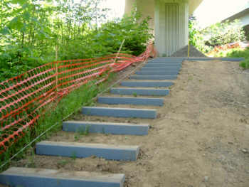
L-10 The map shows a segment of 3rd extending north to the SE
edge of George Himes Park. It's not there.
L-10 The Custer path is directly under the I-5 northbound on
ramp from Terwilliger--the on ramp serves as a rain shelter for the steps.
PICS
 . .
As shown
. . . . . . . . . . . . . . . . . . . .As
is
..
N/O-17/18
 . . A wide gravel road connects the large turnaround at the end of Mary Failing
with Terwilliger. South end of Corbett Hill has a gate to stop
vehicles, but pedestrians and bikes can go through. .
A wide gravel road connects the large turnaround at the end of Mary Failing
with Terwilliger. South end of Corbett Hill has a gate to stop
vehicles, but pedestrians and bikes can go through. .


NO SOLICITORS & SCOOP
M-16 Tryon Creek State Park entrance road and parking lot not
shown.
Showing
the creeks in the park would be helpful--it tells a lot about the terrain.
L-15 The southern piece of Colony does not allow vehicular
traffic as implied by the map. There's a high fence here with a gate
that's usually unlocked for pedestrian access.
K-13 The streets and path at 7th/8th and Primrose don't seem
quite right. PICTURES
 . .
......As shown..........It's
more like this.
M-13 Palatine Hill Rd is incorrectly labeled "Primrose."
Also,"CORBETT LN"
is far enough north that it implies that Palatine Hill Rd is Corbett Ln
at that corner. I don't think that the piece of Alice Ct is really
there..

O-14/15 Radcliffe is a wierdly named street here: it wiggles
through the neighborhood. On the map, the "RIVER" part of "RIVERDALE"
is actually part of Radcliffe--the "DALE" part is Riverdale.
What looks like a N-S section of Hedlund north of Riverdale is actually
Radcliffe.
 SEE
PDX MAP (and
note treatment of trails into Lewis & Clark Col. A person using
the SW Walking map would not be able to use the map to find the trail to
Riverdale if they are coming from the College. Also, should the college
have some kind of color tint indicating the boundaries of the campus?)
SEE
PDX MAP (and
note treatment of trails into Lewis & Clark Col. A person using
the SW Walking map would not be able to use the map to find the trail to
Riverdale if they are coming from the College. Also, should the college
have some kind of color tint indicating the boundaries of the campus?)
O-16 Buddington at Avetine Circus This is a
strange situation. The main E-W street here is not shown on the Walking
Map. It extends east of Avetine Circus, one block north of the street
that is shown on the map--and opposite the short piece (Buddington Ct)
shown extending west of Avetine Circus. The PortlandMaps GIS information
suggests it might be a private street. It extends all the way to
the back (north) gate of Berry Botanic Garden SEE
PDX MAP (I
neglected to show Buddington Ct.) |
|
North - West (map
back)
C-7 A concrete sidewalk connects the west end of Flower
with the north end of 65th.
A/B-9
 1. OES
has recently built a system of trails in their natural area here.
1. OES
has recently built a system of trails in their natural area here.
2.
A heavily used trail connects the playground (via a gate in the fence on
the north side) of Montclair School to Vermont (and Nicol) which goes through
the north edge of the playing fields of OES.
3.
Trails are being conisdered for Bauman (Scholls?) Park, possibly extending
through to Willowmere.
A-7 Raleigh Hills School looks as though on Hazlenut Ln.
It's on Scholls Ferry Rd.
C-6 Hamilton Wy is missing. It's a dead end street
between Hamilton St and Seymour extending east from Shcolls Ferry Rd.
E-5 The part shown as trail is a street and is 58th Dr
with auto access only from Patton Rd from the north. Windsor Ct is
the street to the east of what is shown as trail. The 58th Dr development
is separated from Windsor Ct with a bed of stream boulders, and a foot
path is provided (on the right in the photo below).

MAPS
(from previous corrections)
PHOTO
(from 58th Dr) |
 Looking west from Windsor
Ct across rocks
Looking west from Windsor
Ct across rocks
|
(B-4 There used to be a set of stairs from
the south side of Canyon Rd, leading to an open vacant slope below, that
lets a pedestrian go from Canyon Rd to Canyon Dr. It was a little
north of Linden Rd. I don't know if it's still there--we haven't
used it in years.) |
South - West (map
back)
C-12 Moonshadow Park trails not shown. Street from Orchid
down to Moonshadow development doesn't exist.
 . .
B-11 There is a path going north into a housing development
from a bit east of the Garden Home Community Library. It is made
of concrete slab stepping stones and is heavily used.
B-12 A path connects the gap shown on 74th between Stewart and
Alden.
|


