|
List of map errors and likely problems.
1. Gated community of Catlin Crest. The streets are closed
to walkers.
2. Main St between 57th and 59th missing.
3. West end of Mill missing: also connection to Clay via 60th
and Clay missing.
4. Taylor Ct missing. Also 58th from Taylor Ct.
5. Hewett at Humphrey is mislabelled "58th."
6. Pedestrian connection from end of Hewitt to Skyline missing.
7. "Grant St." missing at Humphrey
8. Wyndham does not intersect with Fairview.
9. Many stairs missing in the Vista - Montgomery area.
(Some are public.)
11. St Thomas More is located incorrectly.
12. A piece of Pointer has been axed by ODOT. It's no longer
there.
13. 40-mile trail is incorrectly shown at Hy 26 (Several
other places, too, but this one will cause problems.)
14. Renee stairs missing/ CLICK
HERE
15. Important school route at Ridgewood and Northshire not shown.
16. Dogwood to Sharon is an important pedestrian route: map indicates
they don't come very close.
17. SW 73rd is incorrectly shown as going a bit south of Sharon
18. The map indicates that 58th Drive is accessible by auto from
Windsor/Thomas; should show the path.
19. The map incorrectly shows switchbacks on the traversing section
of the 40-mile trail above the nature center.
20. The south end of Council Crest Dr is incorrectly labelled
"19th."
21. A streets is shown through the KGON tower (Awful Tower) property
where there is actually a trail.
22. Lee east of 42nd is mostly paved street rather than all trail
as shown. (New trail is now cleared here.)
23. The Admiril Ct trail is incorectly shown as a street. CLICK
HERE
24. The trails in Himes Park join above the stairs, not below
as shown.
25. The break in 62nd Dr at the county line is not shown. CLICK
HERE
26. The large break (primitive trail here) in 74th south of Barbara
is not shown (street is shown). CLICK
HERE
27. SW 77th north of Spruce is incorrectly shown as a street.
It isn't even a good pedestrian route. CLICK
HERE
28. The break in Vacuna between 37th and 39th is halfway between
those streets, not at the 37th end as shown.
CLICK
HERE
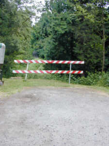
29. The barricade in 27th a little west of Lancaster not shown.
CLICK HERE
30. Mary Failing is shown with no street connections to it.
Pieces are missing at both ends. CLICK
HERE
31. There should be a piece of trail shown at the south end of
Corbett Hill. CLICK
HERE
32. Llewellyn School is incorrectly shown in Oaks Bottom.
33. Hamilton Ct east of Scholls Ferry Rd is missing. CLICK
HERE
34. The inaccessible section of Slavin road is shown as a usable
street.
35. St John Fischer is shown were St Luke's is located.
36. The street south of Idaho Terr is missing,
37. The trail section of 48th north of Iowa is missing. CLICK
HERE
38. The street that drops down to Beaverton Hillsdale Hwy from
Martha and 49th isn't shown.
39. Martha at the same place is shown at right angles to its
actual orientation.
40. Terri Ct path south of Vermont is incorrectly shown as a
street. CLICK
HERE
41. The Greenway path as it rounds the big red building at its
north end is incorrectly shown as being a street.
42. Only one of the two sets of stairs (both sides of Front)
is shown going from Front to the ped tunnel below.
43. The streets around Eagle Point (Lowell and Terwilliger) are
still shown with many errors.
45. The Exercise trail from Hamilton up to Terwilliger is missing.
46. The street going southwest from 35th and Stephenson is "Walking
Woods," not "Woods." CLICK
HERE
47. The street shown as "Condolea" is an alleyway behind the
condos. There's a whole grid of Condolea's. CLICK
HERE
48. The southern end of Abelard is a fenced and locked RV storage
area .CLICK
HERE
49. Peters Road does not extend north to Aquinas: it now ends
a few yards north of Vermeer. CLICK
HERE
50. Riverdale and Radcliffe are still not named correctly.
51. Daphne doesn't go very far south of Radcliffe (called "Rivedale."
on the map) CLICK
HERE
52. Maus is apparently is public; it just looks
like a private street (in many ways). CLICK
HERE
53. Buddington is a named street, but a street just to the north
has many more houses on it, and it's not shown.
54. There is a formal entrance to the PCC campus, north side,
at 53rd. CLICK
HERE
ADDED June 17
55. The 40-mile trail at Marquam Hill Rd
has a 400-ft jog which requires walking on the street.
see: previous
corrections THIRD ROW OF
MAPS
It
is the part in black: I didn't correct the original here.

Riverdale, Radcliffe,
and Hedlund intersect
in a rose bush.
First page
Second Page
Third page

SW 74th does not connect
Barbara to Landau.
|
 SW 77th does not connect
Spruce to Pine.
|
|


